Click here to view a transcript of the above video.
As part of the HydroScheme Industry Partnership Program (“HIPP”), MMA Offshore was awarded the contract to undertake the Lord Mayor Shoal to Pitt Shoals Hydrographic Survey by the Australian Hydrographic Office (“AHO”) on behalf of the Australian Government. The purpose of the hydrographic survey is to facilitate the safe navigation of domestic commercial, military and recreational vessels in the region and to provide confirmation of known, and identification of unknown navigational hazards. The bathymetry data delivered to the AHO will be used to update Australian Hydrographic Office navigation charts.
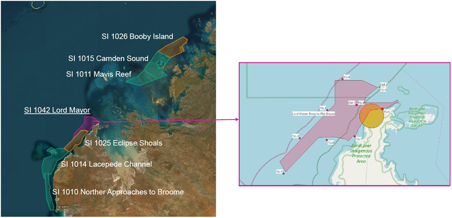
The Lord Mayor Shoal to Pitt Shoals survey area is located in the Kimberley Marine Park, extending North-East from previous HIPP surveys along the inshore route through Lacepede Channel towards Cape Leveque and King Sound. The survey area includes Lord Mayor Shoal, North of Pender Bay and Pitt Shoals, North of Cape Leveque. The total survey area is approximately 212 square nautical miles (approximately 393km). The offshore campaign will span for approximately three months – from 10 October 2023 to 2 December 2023.
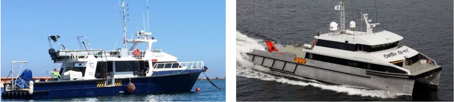
Photo: Third-party project vessels “Empress” and “Outer Limit”
MMA will be using a third-party vessel (“Outer Limit”) as the primary vessel for 24-hour operations in non-shallow areas, supported by a second, smaller third-party vessel (“Empress”) which will be deployed for 12-hour daylight survey works in shallow water. MMA will also be using a range of subsea equipment throughout the project including multibeam echo sounders, seabed tide gauges, seabed current metres, oceanographic tide buoys and low earth orbit (LEO) Starlink Satellite Communication Technology.
MMA will be employing a team of MMA Surveyors, Data Processors and Survey Engineers. The Empress will carry 8 crew and the Outer Limit will carry 16 crew.
To ensure the protection and conservation of the ecologically and culturally sensitive environment in which the project takes place, MMA has developed strong collaborative relationships with several local community groups, government departments and relevant stakeholders. These stakeholders include Parks Australia, the Bardi and Jawi Niimidiman Aboriginal Corporation, the Department of Biodiversity, Conservations and Attractions (“DBCA”) and the Department of Climate Change, Energy, the Environment and Water (“DCCEEW”). Working in accordance with our Australian Industry Capability and Indigenous Participation Plan, MMA has also provided marine mammal observer training to several Bardi and Jawi Indigenous rangers prior to project mobilisation, with the rangers to be employed offshore by MMA to conduct marine mammal observation scopes onboard the survey vessels.
For further information on the project, please visit https://www.hydro.gov.au/NHP/, or contact program manager, Chris Kennedy, on +61 8 9431 7431.
About HIPP
The Australian Hydrographic Office (AHO) is part of the Australian Government Department of Defence. It is responsible for providing Australia’s national charting service under the terms of SOLAS and the Navigation Act 2012 (Cth). The HydroScheme Industry Partnership Program (HIPP) is the AHO’s commercial acquisition program that undertakes focused hydrographic survey activities to contribute to national charting priorities. The vision for HIPP is to undertake an efficient, effective and sustainable hydrographic survey, oceanographic and marine geophysical data collection program through a partnership with Industry to deliver a true nation-building effort.